
Less than three hours from Tokyo by Shinkansen, the Tazawako and Nyūtō Onsen region offers a perfect escape for nature, hiking, and onsen lovers. Between an active volcano, wild forests, late snow, and hot springs lost in the mountains, this discovery of Akita Prefecture provides an experience quite different from the classic itineraries in Japan.
These three days combine hiking on the Akita Komagatake volcano, relaxation in the famous onsens around Nyūtō Onsen, and a bike tour of Lake Tazawako. Everything remains doable without a car thanks to public transport.


Overview
Day-by-day itinerary
DAY 1 – Mount Akita Komagatake
While looking at OpenStreetMap around my hotel, I spotted a hike leading to a mountain lake and then to the summit of the Akita Komagatake volcano. On the map, it looked ambitious but doable in a day. That was all it took to convince me.
Ascent, alpine lake and summit
The first part goes through a dense forest where the presence of bears is very real. The trail is clear but sometimes overgrown with vegetation. You walk while staying alert to the slightest noise in the bushes. It wakes you up more effectively than a canned Japanese coffee.
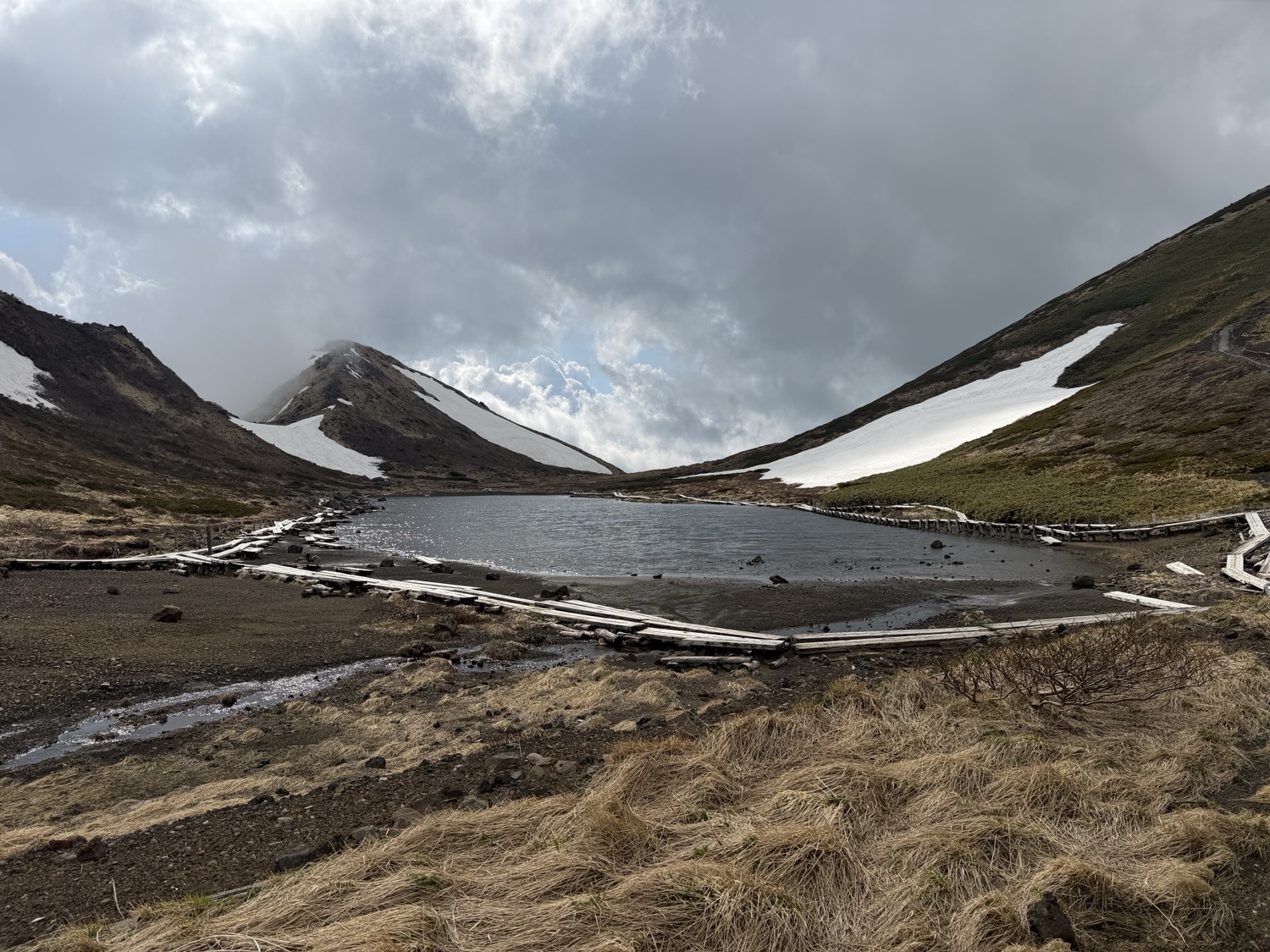
After a steady climb, the forest gives way to a beautiful open ridge with great views of the surrounding mountains. The terrain gradually becomes volcanic. Gravel replaces the vegetation, but the ascent remains relatively comfortable up to the first summit, Ondake, shrouded in clouds.
I then descend towards a splendid alpine lake near which there is a mountain hut. A few patches of snow still remain and slow down progress.
Following that, a staircase leads to the highest point of the hike: the Akita Komagatake stratovolcano, at 1637 meters altitude. It is the highest peak in Akita Prefecture. When the clouds clear, the views of the region are magnificent.


Slippery descent
I retrace my steps towards the lake and then continue towards the north face of the volcano heading to the eighth Komagatake hut. The trail is generally good but several long sections remain heavily obstructed by snow, sometimes on steep sections with no visible tracks. This part requires experience and great caution.
From this hut, the paved road then winds down to the main road. It generally reopens to traffic around June 1st.

GPX and feedback
Although magnificent, this hike around Mount Akita Komagatake is clearly challenging and adventurous. Between an active volcano, late snow, and the presence of bears, it requires good conditions and serious preparation. I advise you to read the precautions to take listed in the practical tips.
The GPX track1 is available here (20.6 km loop starting from Kamenoi Hotel Tazawako, elevation gain: 1,220m).
For a more accessible version, from June 1st you can take the bus via the Komagatake Line to the hut and do the most beautiful section. The schedules shown on Google Maps seem reliable but it is still better to check directly with the bus company.

DAY 2 – Nyūtō Onsen
After the long hike of the previous day, a change of atmosphere for this second day dedicated to the famous hot springs around the village of Nyūtō Onsen.
Kuroyu and Ganiba Onsen, in the village of Nyūtō Onsen
I reach the village by bus to the Kyuka Mura stop. Even before reaching the hot springs, a short easy trail crosses a wetland full of flowers. In mid-May, the white skunk cabbages (thanks PlantNet) are worth the short detour.
The first onsen of the day is the very famous Kuroyu Onsen. This place has a deliberately rustic charm. The facilities are simple and sometimes a bit makeshift, but the staff ensures an authentic and very welcoming atmosphere. Two different sources feed respectively a mixed area and a separated area, both having an indoor bath and an outdoor bath.
The onsen is open to day visitors from 9am to 4pm, except Wednesdays. The entrance fee was 800 yen when I visited.
I then continue towards Ganiba Onsen via a pleasant forest path. I finally decide not to stop there but the setting looks superb.


The route I planned to follow in the valley seemed private. After venturing a bit too far, I ended up directly at an outdoor bath where I clearly wasn’t supposed to arrive but which fortunately looked mixed. Slightly embarrassing moment but at least it confirmed that the place looked magnificent. This mistake has been removed from the GPX track.
Snowy plateau towards Tsurunoyu Onsen
So I veer onto the upper path that climbs towards a plateau at around 1000 meters altitude. In mid-May, the snow is still very present. The hike mostly goes through forest but occasionally offers beautiful openings towards Mount Akita Komagatake.

Going down you reach Tsurunoyu Onsen, the last one of the day. The staff seemed a bit less friendly and it felt more touristy. However, a Japanese family I got along with and the beauty of the place made the experience memorable.
The onsen is open to the public from 10am to 3pm and closed on Mondays. The entrance fee was 700 yen when I visited.


I went back along a track that joins the main road and the bus stop. My hotel being relatively close, I finally decided to walk back.
GPX and feedback
This walk was pleasant and the snowy section very beautiful. However, without adequate equipment, I rather recommend doing it from mid-June onwards. Conditions are then simpler, both for snow and for bears as detailed in the precautions to take listed in the practical tips.
The GPX track1 from Kyuka Mura to the Kamenoi Hotel Tazawako is available here (14.6 km, positive elevation gain: 623m, negative elevation gain: 746m).
For people staying at one of the Nyūtō Onsen establishments, it seems there is a way to buy a pass giving access to seven onsens in the village.
DAY 3 – Lake Tazawako
For this last day, head to the magnificent Lake Tazawako, seen almost everywhere during the previous hikes.
With its crystal clear waters and turquoise color, the lake is spectacular. It is the deepest lake in Japan with more than 420 meters of depth. Despite its more touristy side, the atmosphere remains very calm, especially early in the morning.
I chose to bike around it. Rentals are available here although the rates are a bit high. The complete 20-kilometer loop took me about an hour and a half at a leisurely pace.


I definitely recommend biking or possibly running for long-distance enthusiasts. The terrain is quite flat despite a few small hills (150 meters of elevation gain).
After returning the bike, I swam on one of the lake’s beaches. The water was particularly fresh. Ideal to conclude this trip around Tazawako between hiking and onsen hopping.


Lockers are available where the bus stops. This can be convenient if you want to explore the area before taking the train directly from Tazawako Station.
Practical tips
Budget
Unsurprisingly, the Shinkansen trip from Tokyo is expensive. But fortunately the line is covered by the JR Pass and the JR East Pass.
The Tazawako region itself remains relatively affordable for Japan.
Excluding the transportation to get to Tazawako, I spent about 11,000 yen per day. Here is a breakdown of the main expenses I had:
- Hotel with half board: about 8,000 yen per night for a single room (see accommodation section). For lunch, I bought snacks at the supermarket in Tazawako.
- Onsen entrance: between 700 and 1,000 yen.
- Bus ride: 950 yen for the entire line connecting Tazawako Station to Nyūtō Onsen, where the hiking start points and onsens are located. However most of the time you only do short sections. Note that several hotels offer free shuttle services.
Duration
Three days seemed perfect to go hiking and go onsen hopping in the region around Tazawako without a car.
Accommodation
I stayed at the Kamenoi Hotel Tazawako. The rooms were quite basic, poorly insulated and without real blackout curtains. On the other hand, the hotel’s onsen were very pleasant, the buffets varied and good, the staff very welcoming, and the value for money unbeatable with a rate around 8,000 yen per night for one person on half board (booked on Trip.com).
The location, accessible by bus from Tazawako Station, was convenient to go hiking and onsen hopping.
Precautions to take
Snow
I did this trip in mid-May and snow was still very present on several trails from 600 meters altitude, especially on north-facing slopes. Small crampons, trekking poles, and gloves are highly recommended. However, the weather was magnificent and the trails deserted.

Bears
Bears are very present in the Akita region. Every year, several incidents are reported.
The most common precautions are:
- Make noise regularly to signal your presence (bell, radio, …);
- Avoid leaving food or waste (for you and future hikers);
- Hike in a group when possible;
- Be especially cautious in the presence of cubs because mothers are known to be particularly aggressive to protect their young;
- Prefer daytime hours;
- The Kumamap website lists recent bear sightings in several Japanese prefectures, including Akita.
It is useful to check with your accommodation before going hiking.


Volcano
Mount Akita Komagatake is an active volcano. Before any hike, it is advisable to check the alerts and recommendations published by the Japan Meteorological Agency. In case of eruption, the Amida-ike Pond hut has helmets.


Recommended season
The best time to visit Tazawako is from mid-June to October.
In May, the landscapes are magnificent and very uncrowded but snow can complicate some hikes. Autumn also looks superb thanks to the colors in the mountains.
Transport
The Akita Shinkansen line connects Tokyo to Tazawako in less than three hours.
The region can be explored quite easily by public transport thanks to the Nyuto Line bus connecting Tazawako Station to the village of Nyūtō Onsen. It allows access to the hike starting points and the various onsens.
Many travelers recommend a car to explore the region, but for a short stay, public transport is more than sufficient with a minimum of organization.

Other hikes and nature getaways
Love hiking? Discover more ideas for multi day hikes across different countries here:
- Michinoku Coastal Trail north: 10 days between Iwate and Aomori
- Nepal – the Three Passes Trek & Everest Base Camp (+GPX)
- Alta Via 2: 10 days of hiking in the Dolomites (+GPX)
- Norway – Great Crossing of the Lofotens in 7 days
(1) The GPX tracks mentioned in this article are provided for reference only. They should not be followed as an official guide or a safe route. Mountain conditions are constantly changing and can make a route unsuitable or dangerous.
Leave a Reply