
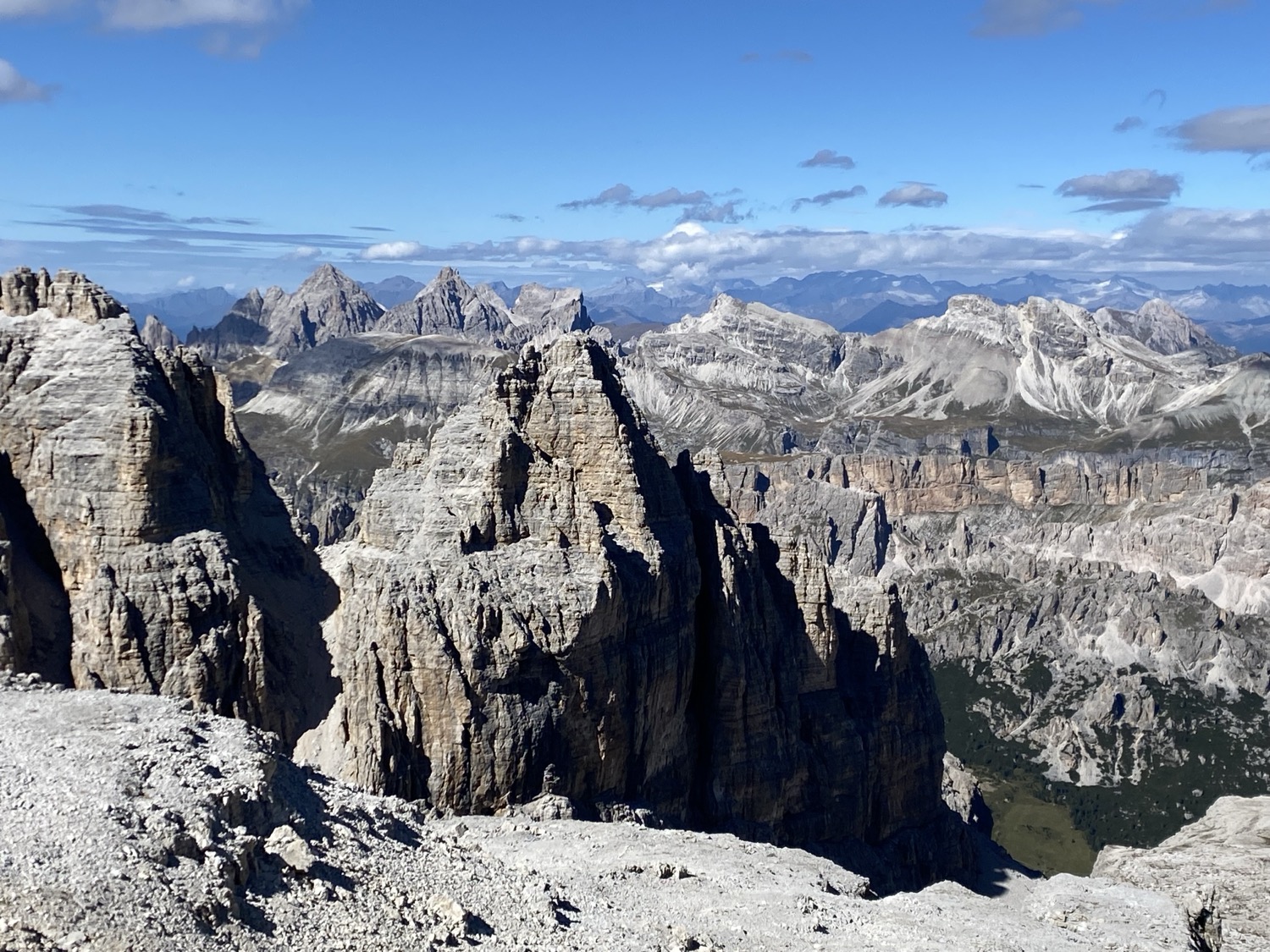
Alta Via 2 crosses the Dolomites via airy via ferratas, welcoming mountain huts, and peaks with breathtaking views. It is a demanding traverse of 155.4 km and 11,400 m of elevation gain. We hiked it in reverse, from south to north, in 10 days with my father in September 2025. I share my day‑by‑day journal with distances, elevation profiles, GPX files, and all my practical tips.


Table of Contents

Daily itinerary
DAY 1 – Croce d’Aune to Rifugio Giorgio Dal Piaz
5.87km – 951m ascent and 0m descent
I meet my father in Venice and, after a night near the station, we head north. Two trains and a bus later, we arrive at Croce d’Aune, the starting point (or ending point) of the Alta Via 2 in the Dolomites. We gulp down a last coffee hoping the pouring rain will stop, but no luck. We put on our jackets and off we go. The trail winds pleasantly through the forest. After two hours of walking, we reach Rifugio Giorgio Dal Piaz soaked to the bone. The hut is very basic. It’s the only one on this route with Turkish toilets and no shower. However, the welcome is warm, with a crackling stove that is perfect for drying our gear. At the end of the day, the clouds part, revealing the surrounding mountains.


DAY 2 – Rifugio Giorgio Dal Piaz to Rifugio Bruno Boz
13.64km – 684m ascent and 943m descent
As soon as we wake up, the rain has definitely cleared and the view has opened up. We set off under a radiant sky. The peaks emerge from the clouds, giving the impression that the world disappears at the foot of the sheer cliffs. The trail is pleasant, despite a few narrow sections where the void is felt. In the early afternoon, we reach Rifugio Bruno Boz. We spend the afternoon resting and reading in the sun.


DAY 3 – Rifugio Bruno Boz to Passo Cereda
13.55km – 914m ascent and 1234m descent
The sun is still shining, while a few clouds dance around the peaks. The trail follows steep slopes. Gradually, the sections become more technical. As a result, we have to use our hands to climb or downclimb some rocks. We pass by Bivacco Feltre-Bodo, an unstaffed shelter, and cross Passo del Comedon without difficulty. We then begin the descent to Passo Cereda. It is steep, unstable, and demands all our concentration: stones roll under our feet. After a final section through the forest, we reach our hut, which turns out to be a hotel. So, private room, unlimited hot showers, and a good meal offer a welcome contrast.


DAY 4 – Passo Cereda to Rifugio Pradidali
16.35km – 2273m ascent and 1324m descent
This is the biggest stage. The huts were full for Saturday night, so I had to find an alternative. Result: a day with 2,273 m of positive elevation gain. Fortunately, the weather is on our side: clouds filter the sun without spoiling the scenery. After a first climb of 1,000 m, we go back down to Rifugio Treviso for a lunch break, where most hikers stop.
Then we tackle the second climb, 1,200 m of ascent. Up to the pass, the trails are good, although steep. Along the way we pass the Bivacco Carlo Minazio, an unstaffed shelter where we had considered staying, but seeing the crowds around it, we figure it’s not so bad that we found a spot at the next hut. The descent turns out to be more technical: sheer walls and a few via ferrata sections. Just before nightfall we finally reach Rifugio Pradidali, tired but happy.


DAY 5 – Rifugio Pradidali to Rifugio Volpi Al Mulaz
13.36km – 1194m ascent and 901m descent
After a night in a small, damp four‑person room, we set off for an intense stage. First we need to finish the portion left unfinished the day before. Then we tackle the day’s stage, rated 3+, the hardest level on the Alta Via 2 in the Dolomites. After a first pass, we cross a few via ferrata sections. Then we find a good trail from which we spot chamois. The path zigzags up to Rifugio Rosetta, perched on a pass offering a splendid view. A sandwich and coffee stop.
The following descent goes through a valley punctuated by sections equipped with cables, then the trail climbs back up into a majestic cirque where peaks soar all around us. The further we go, the steeper the slope becomes, until we reach sheer walls that we have to overcome with the help of welcome ladders and cables. Despite the sustained effort, the panoramas are simply spectacular.
Finally, a descent through a vast boulder field where the GPS usefully guides us leads us to Rifugio Volpi Al Mulaz. After this stage, without doubt our favourite so far, we even have the luxury of having a drink while admiring the view, before enjoying a hot shower and a delicious meal.


DAY 6 – Rifugio Volpi Al Mulaz to Rifugio Albergo Miralago
13.54km – 462m ascent and 1105m descent
Another magnificent day. After a short steep section to get our legs going, we quickly find gentler descending trails where the kilometres fly by without too much effort. We leave the natural park and cross a ski resort that is a bit less interesting before reaching Passo San Pellegrino, a starting point popular with day hikers. We then arrive at Rifugio Albergo Miralago, which looks more like a hotel than a mountain hut, just in time for lunch. The afternoon passes peacefully between relaxation and recovery.


DAY 7 – Rifugio Albergo Miralago to Rifugio Marmolada Castiglioni
26.04km – 1682m ascent and 1531m descent
The day promises to be intense: 1,200 m of positive elevation gain and 21 km on the programme. Confident, I start the GPS. Little by little, the proper trail turns into a narrow path that zigzags through a vast, increasingly steep boulder field, up to the first pass. There, a sign indicates the official direction of the Alta Via 2 in the Dolomites, which does not match my GPS.
We struggle with the wind to open the map and realise that we have taken a variant leading to the glacier, impassable without equipment. The GPS track deviates from the official route but remains doable, at the cost of an extra 500 m of elevation gain. Fortunately, the scenery is up to par: we follow the southern face of Marmolada, the highest peak in the Dolomites, as far as Rifugio Onorio Falier where a good lunch restores our energy. We head towards Malga Ciapela. After vainly hoping for a bus (which runs only in winter) and trying a bit of hitchhiking, we finally walk up to Rifugio Marmolada Castiglioni via the ski slope. When we arrive, what a pleasure to put down our packs!
In retrospect, we are glad we took the variant, which was very beautiful (though intense). However, the last few kilometres on the ski slope are really not interesting. When doing the trek from north to south, Rifugio Marmolada Castiglioni arranges a shuttle in the morning to avoid them. If, like us, you are going from south to north, I recommend contacting the hut in advance to see if it is possible to arrange a shuttle from Malga Ciapela.


DAY 8 – Rifugio Marmolada Castiglioni to Rifugio Pisciadu
16.26km – 1357m ascent and 811m descent
The day starts with a tough climb, then follows a hillside trail facing the Marmolada glacier (or what’s left of it). Quickly, we encounter more and more tourists. We soon understand why: a cable car provides easy access to this path. The descent is via a ski resort to Passo Pordoi, then we climb back up towards the Piz Boé massif, which we go around. The views are very different from anything we have seen so far: a surprisingly desert‑like landscape. This is the busiest stage so far.
At Rifugio Boé, we realise that we are gradually arriving in a more German‑speaking part of Italy. The menu is now translated into 4 languages: Italian, English, German, and a language I don’t recognise. After some research, I understand that we are in Ladinia, where Ladin is one of the languages used!
Once past the hut, the crowds disappear. Then a spectacular panorama opens up before us: a dizzying canyon that we follow before descending to Rifugio Pisciadu via a small, perfectly equipped via ferrata section.


DAY 9 – Rifugio Pisciadu to Rifugio Puez
10.13km – 625m ascent and 734m descent
After a light breakfast, we start the day with a long via ferrata under a brilliantly blue sky. The trail descends into the valley before climbing back up the other side, amid a crowd of tourists. Yet, once past the first viewpoint, tranquillity returns and we continue almost alone across a vast plateau. We reach Rifugio Puez in the early afternoon and enjoy the sun reading in the grass. This perfect break allows us to recharge our batteries before the final stage.


DAY 10 – Rifugio Puez to Plose lift then Brixen
26.65km – 1265m ascent and 1687m descent
We start this final stage at dawn. Little by little, stars and moon fade away, giving way to the ochre hues of sunrise illuminating the jagged reliefs. After one last via ferrata, we enjoy the quiet of the morning. Moreover, we are lucky enough to spot about forty chamois in the valley. We pass by the beautiful Rifugio Genova (Schlütterhütte), where German definitively takes precedence over Italian. We would have liked to break the stage here, but the hut was full.
Further on, a very busy section reminds us of the popularity of these trails. Then tranquillity returns as we plunge into the forest. The end of the route crosses a less inspiring ski resort where Rifugio Plose is located, under renovation during our visit. We continue along the path to Valcroce, where we decide to cut the stage by taking a cable car down, followed by a bus to Brixen – a bit expensive, but our knees thanked us! Thus ends this magnificent hike.


Brixen (Bressanone): we treat ourselves to a well‑earned break in a beautiful hotel in this pretty town. Relaxing sauna, delicious meal, restful night, and good breakfast gently close this adventure, before heading back.


Distance and elevation table
| Day | Start → Finish + GPX(1) | Distance | Ascent / Descent |
|---|---|---|---|
| 1 | Croce d’Aune → Rif. Giorgio Dal Piaz | 5.87 km | +951 / -0 |
| 2 | Rif. Giorgio Dal Piaz → Rif. Bruno Boz | 13.64 km | +684 / -943 |
| 3 | Rif. Bruno Boz → Passo Cereda | 13.55 km | +914 / -1234 |
| 4 | Passo Cereda → Rif. Pradidali | 16.35 km | +2273 / -1324 |
| 5 | Rif. Pradidali → Rif. Volpi Al Mulaz | 13.36 km | +1194 / -901 |
| 6 | Rif. Volpi Al Mulaz → Rif. Albergo Miralago | 13.54 km | +462 / -1105 |
| 7 | Rif. Miralago → Rif. Marmolada (via variant) | 26.04 km | +1682 / -1531 |
| 8 | Rif. Marmolada Castiglioni → Rif. Pisciadu | 16.26 km | +1357 / -811 |
| 9 | Rif. Pisciadu → Rif. Puez | 10.13 km | +625 / -734 |
| 10 | Rif. Puez → Plose lift / Brixen | 26.65 km | +1265 / -1687 |
| Total | Full GPX | 155.40 km | +11,407 / -10,270 |
(1)The GPX tracks mentioned in this article are provided for reference only. They should under no circumstances be followed as an official guide or a safe route. Mountain conditions are constantly changing and can make a track unsuitable or dangerous.
Practical tips
Getting to the start and from the finish
Getting there: from Venice, we took the train to Feltre followed by a bus to Croce d’Aune. Google Maps schedules seemed correct.
Return: Brixen is quite well connected by train. We took a train reserved well in advance to go to Austria, then on to Germany and finally Belgium.
Budget
Expect between 60 and 90 euros per day per person for half‑board in the mountain huts. Hotels like those in Passo Cereda or Brixen are more expensive (220 euros per night for two people). Allow extra for cable cars and shuttle buses. Lunches can generally be ordered on site but were often disappointing. We ended up trying to eat at huts midway (around 15 euros per person).
Duration
The classic route, described in the reference guidebook “Trekking in the Dolomites” by Gillian Price, is planned for 13 stages. However, we completed it in 10 days, conditioned by hut availability, by doubling some stages and skipping part of our last stage between Rifugio Città di Bressanone and Bressanone where we took a cable car down. The doubled stages were particularly intense.
Gear
In addition to standard hiking gear, many people choose to take via ferrata equipment: helmet, lanyard, and harness with suitable quickdraws. For our part, we hesitated for a long time but finally decided to go without, and we did not regret it.
Since we were hiking in the opposite direction to most hikers, we were hardly exposed to rockfalls. However, in the classic direction and on busier sections, the risk is probably much higher, which can make a helmet useful, even essential.
We had neither harness nor lanyard, but we both do a little climbing and had relatively dry conditions on all the via ferrata sections, which allowed us to tackle the most dizzying passages calmly. Some sections do require climbing or downclimbing on exposed terrain. If you are not completely comfortable with this type of terrain, it is probably better to take via ferrata equipment.
Finally, a compact, light, well‑adjusted backpack greatly improves comfort on these technical sections and makes movements easier.


Mountain huts, reservations and discounts
The mountain huts on the Alta Via 2 in the Dolomites offer dormitories and sometimes private rooms. Some stages like Passo Cereda or Miralago are real hotels. Book several months in advance. Note that weekends are particularly busy.
There is no centralised booking system, so you have to contact them individually, which makes logistics a bit tedious. I organised it late (in June for a September departure), and availability pushed us to do the route in reverse.
Here is the list of huts from south to north that I compiled during my research:
| Refuge | Website | |
|---|---|---|
| Rifugio dal Piaz | https://www.rifugiodalpiaz.com | |
| Rifugio Boz | https://www.rifugioboz.it | info@rifugioboz.it |
| Rifugio Cereda | https://www.rifugiocereda.com | |
| Rifugio Treviso | rifugiotreviso@gmail.com | |
| Rifugio Pradidali | pradidali@libero.it | |
| Rifugio Rosetta | https://www.rifugiorosetta.it | |
| Rifugio Volpi Al Mulaz | rifugiomulaz@gmail.com | |
| Rifugio Albergo Miralago | https://www.albergomiralago.com | |
| Rifugio Onorio Falier | http://www.rifugiofalier.altervista.org | |
| Rifugio Castiglioni Marmolada | https://www.rifugiomarmolada.it | |
| Rifugio Boé | https://www.rifugioboe.it | |
| Rifugio Pisciadu | https://www.rifugiopisciadu.it/ | |
| Rifugio Puez | https://www.rifugiopuez.it/en/ | |
| Rifugio Genova (Schlüterhütte) | https://www.schlueterhuette.com | |
| Rifugio Plose | https://www.plosehuette.com |
We hesitated to join the Italian Alpine Club, which would have given us discounts at several of the huts, but we were a bit late. Some huts gave discounts to members of other European alpine clubs.
Unfortunately, camping is forbidden.


Recommended season
The ideal period to hike the Alta Via 2 in the Dolomites is generally from late June to mid‑September, when the huts are open and the trails are normally free of snow.
July and August offer the most stable conditions (sometimes very hot), but they are also the busiest months.
Early in the season, some high‑altitude sections may still be snow‑covered, while late in the season the weather becomes more uncertain, days are shorter, and some huts start to close.
Direction of the hike
We chose to hike the Alta Via 2 in the Dolomites in the opposite direction to the classic route, from south to north, for logistical reasons. Doing it in this direction allowed us to enjoy a quieter and more solitary experience. On the one hand, it allowed us to go through the via ferratas with less risk of rockfall caused by other hikers. On the other hand, it favoured wildlife observation. For example, we saw chamois 6 days out of 10, whereas people we met going the other way told us they had only rarely seen them.
However, the classic direction of the Alta Via 2 in the Dolomites is from north to south, and it has other advantages. First, it is the best choice for those who enjoy meeting people: since the majority of hikers take this route in that direction, you often meet the same people at subsequent stages. The distances and elevation gains are also better distributed, and the via ferratas are designed to be done in that direction (mostly uphill), which balances the days more evenly. Finally, I found that in this direction, the landscapes become more beautiful as the route progresses.

Leave a Reply