
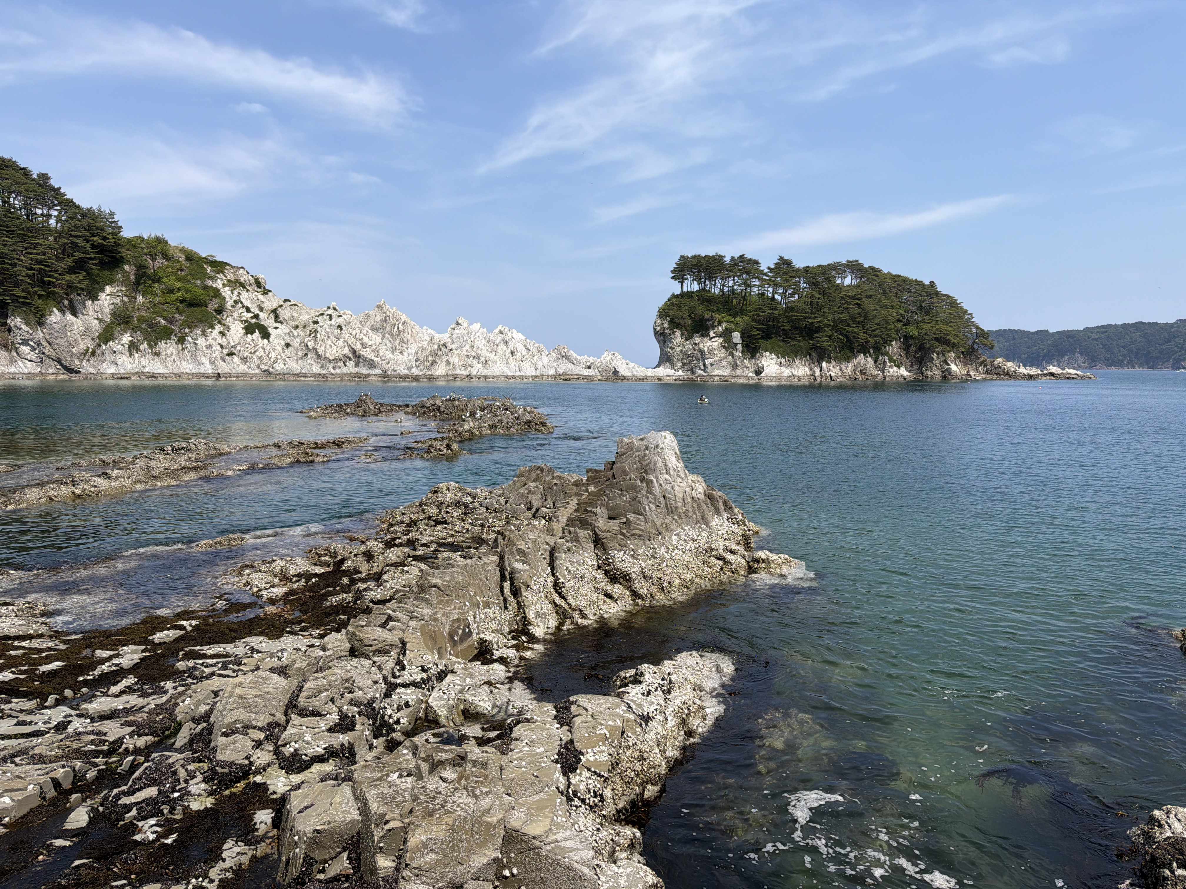
The Michinoku Coastal Trail north is a vast hiking trail stretching along Japan’s northeastern coast for over 1,000 kilometers. This northern section, representing about a quarter of the complete trail, traverses the prefectures of Iwate and Aomori for approximately 260 kilometers.
The route alternates between red pine and bamboo forests, steep cliffs, pebble beaches, wild coves, tunnels carved into rock, fishing villages, and spectacular rocky coastlines between Taro, Tanohata, Fudai, Noda, Kuji, Hirono, Hashikami and Hachinohe.
Some stages offer exceptional coastal views while others go more through forests or secondary roads. The terrain is often rugged with many ups and downs. The trail also passes several memorials and villages rebuilt after the 2011 tsunami, giving this hike a very special historical dimension.
One of the major advantages of this northern portion of the trail is the presence of the coastal railway line, the Sanriku Railway, between Miyako and Kuji, and then the Hachinohe Line between Kuji and Hachinohe. This allows you to hike light while keeping one or more bases for sleeping.


Overview
Trek overview (GPX here)
Day-by-day itinerary
DAY 1 – Miyako to Taro
29.37km – 1239m ascent and 1221m descent
The start of this northern section of the Michinoku Coastal Trail begins with three kilometers of fairly monotonous road where I question my decision to do this hike.


Fortunately, the trail finally turns into the forest. The atmosphere becomes more pleasant. The Tategasaki observation tower is on the route, but unfortunately the view is obscured by vegetation. Then the path goes back down to the superb coastal sections around Jodogahama. Doubts are gone, the hike is worth it! Here, several beaches are connected by tunnels carved into the rock. As it’s a Sunday, some tourists are also enjoying the area. There are a few drink vending machines and a restaurant.


The trail then goes up towards a hamlet marked by the 2011 tsunami. A sign indicates the impressive level reached by the wave. This constant presence of the disaster gives a very special dimension to this northern section of the Michinoku Coastal Trail.
The route continues through bamboo forests, pebble beaches and impressive rock formations, notably the Shiofuki-ana Blowhole which sprays seawater when the waves are powerful. The Anegasaki viewpoint is also superb.


Along the way, the Tsunami Memorial Park Nakanohama preserves several vestiges of the 2011 destruction.


After passing the Miyako Country Club, where we stand out a bit among the golfers, a final section alternating forest and beaches leads to Taro. Arriving in the town leaves an almost post-apocalyptic impression with its immense tsunami walls that sometimes complicate navigation. The town already had protections before 2011, giving residents a sense of security. Unfortunately, the wave far exceeded them.


I finally reach Tanohata, where I will stay for six nights, thanks to the tiny coastal line. See the Accommodation section for more information.

DAY 2 – Taro to Settai
21.28km – 698m ascent and 680m descent
This second day begins again on a quiet road leading to the Earthquake Heritage Taro Kanko Hotel, a testament to the damage suffered by the town of Taro in 2011. The route then joins the impressive Sannoiwa Rocks and then a small wilder portion before returning to asphalt for a good while.
On the road, I come across a large scat that looks like bear droppings. A few minutes later, in the forest, I also come across a snake. Maybe a viper? Anyway, the morning atmosphere is set.
Around the seventh kilometer, I notice that the downloaded GPS track seems strange. After checking with the official Michinoku Coastal Trail north track, I realize that I deviated from the track on a small section. The old route, probably damaged by the tsunami, is still passable, but it’s better to follow the official track.
I join the village of Settai which has a small grocery store not listed on Google Maps as well as a gas station.
In the end, this day starts with beautiful coastal sections but the majority is on long road sections.


It is possible to continue this stage to Iwaizumiomoto to shorten the long stage of the next day, however Iwaizumiomoto station is about 1 km from the trail.
DAY 3 – Settai to Tanohata
28.01km – 1364m ascent and 1363m descent
The trail goes mainly through forests before reaching the Kumanohana Observatory offering nice views of the bay before descending towards Iwaizumiomoto. As in many coastal towns, immense dykes now protect the town.
There are some restaurants and small shops to stock up.
The rest of the day is mainly in the forest with a succession of steep ups and downs and few views. Even though the peaks do not exceed 200 meters, the stairs and terrain make the stage quite physical.
After about 19 kilometers, the trail finally reaches Unosu Cliff, a superb viewpoint accessible by car. Yet, after this long succession of ups and downs, the reward feels much more deserved.
From there, the trail descends to beautiful beaches and joins the fishing village of Shimanokoshi where the beautiful pine island, Matsushima, indeed resembles the homonymous region near Sendai.
One last small section leads to Tanohata where I return to my hotel.


DAY 4 – Tanohata to Fudai
27.77km – 1172m ascent and 1171m descent
The initial section follows the coastal road which offers nice views and passes above a small memorial set up on a beach.
After about four kilometers, the trail reaches the French restaurant L’Auréole. From there, a small path begins to overlook the coast before quickly turning into very steep stairs up to the Rikuchu Bentenzaki lighthouse, offering a nice view of the surroundings.
Then, the trail descends towards the beaches and goes through several pedestrian tunnels whose end is nowhere in sight, as well as a few ladders. Take a headlamp because, frankly, the atmosphere is not very reassuring and you can’t see anything. In the end, apart from three bats, nothing particularly dramatic.


The path then immediately resumes with a succession of stairs up and down to reach the viewpoint of the splendid Cape Kitayamazaki.
Another fairly steep climb then leads to an observation platform accessible via a small detour. The area being quite touristy, a visitor center and restaurants are also nearby.


From this area, the terrain becomes a little gentler. The trail goes through a beautiful forest before reaching the Kurosaki Observation Deck, then descends via stairs to Fudai.
Just before the city, at Nedari-hama, the path briefly follows the coast and the view is absolutely magnificent.


Even if Fudai is not the prettiest town on the route, it has a certain charm. Several locals are out and the atmosphere is particularly lively. I even come across a group of schoolchildren each carrying a bear bell on their backpack.
There seem to be several options to eat in Fudai. However, I didn’t find a real supermarket or a large convenience store.


DAY 5 – Fudai to Noda
25.61km – 784m ascent and 790m descent
After leaving Fudai, the trail quickly joins a humid forest where the path climbs along a small, sometimes muddy stream.
The route then descends to Horinai, where it is easy to catch the train.
From there, the stage becomes much more road-oriented with relatively few interesting views until Noda.
The town of Noda however has a certain charm. There are some pretty houses, a small temple and several options for eating or doing some shopping.
If one stage had to be removed from this itinerary, this would undoubtedly be it.


DAY 6 – Noda to Kuji
25.09km – 862m ascent and 864m descent
Just after passing the Noda fishing port, the path goes around a beautiful cliff made of rocks with particular shapes before following a nice pebble beach for a long time.
After leaving the beach, the route still follows the sea from the road before going back into the forest. From there, the terrain becomes much more sporty. Ups and downs follow each other relentlessly. The path on the hillside is at times a little dizzying and requires a sure foot.
The red pine forest regularly reveals a magnificent turquoise sea.
After several climbs, the trail descends to the port of Kosode where ama still practice freediving fishing during the summer. These traditional female underwater divers are emblematic of several coastal regions of Japan.
The route then follows the road along a spectacular coast where waves crash against the rocks. A small detour allows access to the pretty Gojo Falls. I then continue to Kuji where I deviate from the route to reach the last station accessible with the Sanriku Railway from where I return to Tanohata.
This portion of the Michinoku Coastal Trail north is clearly among my favorites.


DAY 7 – Kuji to Rikuchu-Noda
22.82km – 612m ascent and 572m descent
I leave the Ragaso Hotel with my full backpack and take the train to Kuji. This also marks a railway transition: the previous stages were connected by the Sanriku Railway, while the rest of the route north of Kuji is served by the Hachinohe Line. Changing bases here makes the logistics much easier.
Before leaving the city, I stop at Amber Hall, a cultural center with distinctive architecture designed by Kishō Kurokawa. The panoramic platform offers limited views, but the building itself is worth seeing. Leaving Kuji, the trail follows the massive tsunami walls that dominate this coastline before continuing along a long road section.
A large torii marks the entrance to Itsukushima-jinja. Due to time constraints, I skip the detour, although the peninsula looks beautiful.
After passing through a small village where the Artville Mugyo museum is located, the atmosphere changes completely. The road becomes a track and then a proper forest trail through a beautiful red pine forest with occasional views of the turquoise sea.
This is undoubtedly the highlight of the stage. The trail passes the Yokonuma viewpoint and Samuraiishi, a rock where a samurai is said to have rested around 400 years ago.
The day ends with a surprisingly wild river crossing for Japan: no bridge, no facilities, just removing your shoes to wade across before reaching Rikuchū-Nakano Station. From there, I take the train to my accommodation in Hachinohe for the next four nights.


DAY 8 – Rikuchu-Noda to Kadonohama
25.52km – 355m ascent and 375m descent
The stage begins with a long road section to Uge Station, which I could have done without. Fortunately, the atmosphere changes a little from there when the trail reaches a large beach. Even if the itinerary quickly returns to the road, the landscapes remain pleasant.
The route alternates between small ports, beaches protected by imposing tsunami walls, and villages surrounded by flooded rice fields which, at this time of year, create beautiful mirror effects. The Hachinohe Line, which regularly runs alongside the trail, is particularly photogenic on this section.
After Tamagawa, another long road section leads to Taneichi Beach where a few surfers enjoy the waves. The trail then follows the coastline on concrete paths, sometimes built on top of the tsunami walls, offering beautiful views of the clear water.
The end of the stage returns to the road again to Kadonohama Station, from where I take the train back to my hotel.


DAY 9 – Kadonohama to Hashikami
30.40km – 911m ascent and 897m descent
I was curious to discover this stage as it is one of the few places where the Michinoku Coastal Trail clearly moves away from the coastline. After one last small coastal section passing by the beach at Hashikami Lighthouse, the route takes a long road that gradually climbs to Terashita Kannon, a temple in a magnificent wooded setting.
From there, I expected to find a wilder, more natural atmosphere, but the trail quickly falls back onto the road. Apart from a few rarer, more pleasant sections, this part of the route unfortunately remains fairly monotonous.
We eventually reach the parking area for Mount Hashikami, the starting point of a very pretty trail going up to the summit among blooming azaleas, generally between late May and mid-June. From the summit, the clear views over Hachinohe, the Pacific Ocean and the surrounding mountains are very beautiful.
The descent goes more through the forest to a parking lot, but the itinerary then again returns to the road. With the exception of an impressive horse chestnut tree and a temple, this last portion clearly lacks interest until arriving at Hashikami Station.
Note: it seems possible to only do the upper part of this stage using a bus from Hachinohe, which would avoid a good part of the long road sections.


DAY 10 – Hashikami to Hachinohe
18.82km – 232m ascent and 230m descent
The first part of this stage is mainly on the road, with several sections that are a bit less pleasant due to traffic. However, the landscapes remain very beautiful and varied. The trail passes by several temples, follows several beaches and goes through areas where some buildings damaged by the tsunami still remain.
The itinerary continues like this to the vicinity of Tanesashi Kaigan. From there, the hike becomes superb until the end. You then string together several of the most beautiful sites of this northern part of the Michinoku Coastal Trail: the vast coastal lawn of Tanesashi Natural Lawn, the pine forest of Yodo-no-Matsubara with its magnificent ocean views, the immense Ōsuka sand beach, and then the spectacular Ashigezaki viewpoint.
The official finish is at Kabushima, a shrine built on a rocky islet overrun by black-tailed gulls, whose colonies are particularly impressive in spring and summer. This magnificent section marks the end of the northern part of the Michinoku Coastal Trail. From Kabushima, it’s about one kilometer to Same Station.
Note: as I did this section on a Sunday, I actually did the stage in reverse to start the day at the Tatehana Wharf Morning Market. This morning market, one of the most famous in the region, is definitely worth the detour, even though several stalls start packing up around 8 a.m. while the official closing is at 9 a.m.


Distance and elevation table + GPX
| Day | Stage + GPX(1) | Distance | Ascent / Descent |
|---|---|---|---|
| 1 | Miyako → Taro | 29.4 km | +1239 / −1221 m |
| 2 | Taro → Settai | 21.3 km | +698 / −680 m |
| 3 | Settai → Tanohata | 28.0 km | +1364 / −1363 m |
| 4 | Tanohata → Fudai | 27.8 km | +1172 / −1171 m |
| 5 | Fudai → Noda | 25.6 km | +784 / −790 m |
| 6 | Noda → Kuji | 25.1 km | +862 / −864 m |
| 7 | Kuji → Rikuchū-Nakano | 22.8 km | +612 / −572 m |
| 8 | Rikuchū-Nakano → Kadonohama | 25.5 km | +355 / −375 m |
| 9 | Kadonohama → Hashikami | 30.4 km | +911 / −897 m |
| 10 | Hashikami → Hachinohe | 18.8 km | +232 / −230 m |
| TOTAL (Full GPX) | 254.6 km | +8229 / −8163 m |
The planning and duration section below lists the stations and the distance between them as well as my comments on each of the sections to allow you to possibly lengthen or shorten certain stages as well as target the most interesting sections of the trail.
(1)The GPX tracks mentioned in this article are provided for reference only. They should not be followed as an official guide or a safe route. Mountain conditions are constantly changing and can make a route unsuitable or dangerous.
Practical tips
Beware of bears!
Bears are very present in the region. Several accidents are reported each year.
The most common precautions are:
- Make noise regularly to signal your presence (bell, radio, …);
- Avoid leaving food or waste (for you and future hikers);
- Hike in a group when possible;
- Be particularly careful in the presence of cubs because mothers are known to be particularly aggressive to protect their young;
- Prefer daytime hours;
- The Kumamap website lists recent bear sightings in several Japanese prefectures.
It is useful to ask your accommodation before going hiking.


Markings, navigation and foot traffic
The natural sections of the Michinoku Coastal Trail north are generally well marked and the trails remain easy to follow, even if some intersections can be confusing. In towns and villages, signage is almost non-existent. The markers often have arrows painted in white on the upper part indicating the path.
The Michinoku Coastal Trail GPX track provided by the Michinoku Trail Club seemed essential to me to correctly follow the northern part of the hike, even if it is not presented as an official navigation tool.
For people who prefer to navigate without technology, several topo-guides also seem very well made with photos and visual references allowing you to easily confirm your position on the ground. I managed well without them.
The Michinoku Trail Club website allows you to download their GPX track for free and order these topo-guides: https://m-tc.org/en/.
Several counters are installed along the trail and indicated, during my passage, between 80 and 200 hikers in the previous fifteen days depending on the sections.


Budget for the Michinoku Coastal Trail north
I spent about 110,000 yen for 10 days on this northern section of the Michinoku Coastal Trail, excluding transport to get to Miyako and leave from Hachinohe.
Ouvre le mode canvas
Le canvas est ouvert.
Canvas Espace De Travail
Traduis ça en anglais
| Expense | Details | Approximate Budget |
|---|---|---|
| Southern accommodation | 6 nights at the Ragaso Hotel in Tanohata with half board | ¥60,000 |
| Northern accommodation | 4 nights at the Hotel Livemax Hon Hachinohe Ekimaewithout meals | ¥14,000 |
| Local trains | Daily transport to reach the start and end points of the stages | ¥12,000 |
| Lunches and breakfasts | Convenience stores, small supermarkets, and snacks | ¥15,000 |
| Restaurants in Hachinohe | Local restaurants around Hon Hachinohe | ¥7,000 |
| Miscellaneous expenses | Drinks, vending machines, laundries, and small purchases | ¥2,000 |
| Total | ¥110,000 |
Accommodation
To explore this northern section of the Michinoku Coastal Trail, I chose two main bases to avoid changing accommodation every day.
In Tanohata, I spent six nights at the Ragaso Hotel, an excellent choice to radiate on several stages thanks to the Sanriku Railway line.
I was particularly delighted with the hotel and its extremely welcoming and attentive staff. The half-board meals were varied, generous and well-balanced. I had informed them in advance that I was vegetarian and the team prepared a different menu for me each evening.
The establishment also has baths and a sauna with a sea view. My traditional Japanese room also faced the coast, which made returning from hikes particularly pleasant.
The hotel was heavily damaged during the 2011 tsunami but survived the disaster before being renovated. Knowing the history of the place and the region makes it even more impressive.
For the second part of the trek, I spent four nights at the Hotel Livemax Hon Hachinohe Ekimae right in front of Hon-Hachinohe station on the Hachinohe Line.
The style is much simpler and more functional, with a capsule hotel atmosphere that is less charming but economical. After several nights in a traditional ryokan, the contrast is almost amusing and also allows you to vary experiences. The hotel also has baths and a sauna, very much appreciated after long days of walking.

Planning and duration
I segmented this hike based on train stops in order to maintain great flexibility.
I had initially planned 10 stages before eventually doubling up some sections and reducing my personal itinerary to 7 days. The article however keeps my initial plan which seems balanced for a good hiker.
Below you will find the table of train stations I used to plan my itinerary, to which I added my comments on each stage to allow you to organize your route as best as possible.
Distances are approximate but allow you to define your own stages according to your physical condition. Travelers with less time can easily focus on the most beautiful stages.
Train station and distance table
| Departure | Arrival | Distance | Notes |
|---|---|---|---|
| Miyako | Taro | 29 km | Beautiful stage, long and demanding |
| Taro | Settai | 21 km | Nice first section but less interesting afterwards |
| Settai | Iwaizumi-Omoto | 8(+1) km | 1 km detour to reach the station |
| Iwaizumi-Omoto | Shimanokoshi | (1+)16 km | A lot of elevation gain but great rewards |
| Shimanokoshi | Tanohata | 4 km | Distance to the Ragaso Hotel |
| Tanohata | Fudai | 28 km | Beautiful stage, long and demanding |
| Fudai | Shiraikagan | 6 km | Stage through a humid forest without views |
| Shiraikagan | Horinai | 5 km | Roads and forests with little interest |
| Horinai | Noda Tamagawa | 8 km | Road section with little interest |
| Noda Tamagawa | Tofugara Kaigan | 3 km | Road section with little interest |
| Tofugara Kaigan | Rikuchu Noda | 4 km | Entrance into a pleasant town |
| Rikuchu Noda | Kuji | 23(+2) km | Beautiful stage, demanding elevation gain. 2 km detour to reach the station. End of the Sanriku Railway Line |
| Kuji | Rikuchu Natsui | (2+)2 km | Urban section with limited interest. Beginning of the Hachinohe Line |
| Rikuchu Natsui | Rikuchu Nakano | 20 km | Long road section but then a very beautiful stretch |
| Rikuchu Natsui | Uge | 6 km | Road section with little interest |
| Uge | Rikuchu Yagi | 3 km | Nice beach section followed by a quiet road through villages |
| Rikuchu Yagi | Shukunohe | 3 km | Quiet road with beautiful sea views |
| Shukunohe | Tamagawa | 3 km | Quiet road with sea views, villages, and rice fields |
| Tamagawa | Taneichi | 5 km | Road section with little interest |
| Taneichi | Hiranai | 3 km | Beautiful coastal section |
| Hiranai | Kadonohama | 3 km | Road section with little interest |
| Kadonohama | Hashikami | 31 km | A lot of road walking. Beautiful section around the summit. Bus access available to reduce road portions. |
| Hashikami | Tanesashi-Kaigan | 10 km | Busy road with little interest. Several stations along the way |
| Tanesashi-Kaigan | Same | 9(+1) km | Beautiful stage, gentle elevation gain. Mutsu-Shirahama Station along the way |
Supplies, water and toilets
The route regularly passes infrastructure with toilets, drinking water points and drink vending machines. I had a 1.5 liter bottle with me, which was more than enough, but in summer it is probably worth taking more water.
For food, you regularly come across grocery stores and konbinis. Most of them are indicated on Google Maps, which allows you to anticipate supply points.

Recommended season
Spring and autumn are certainly the most pleasant periods to cover this section of the Michinoku Coastal Trail north. I did it in May, which was perfect.
June is known in Japan as the rainy season.
Summer offers lush vegetation but humidity can make some stages physical.
Terrain and difficulty
The terrain alternates between quiet roads, forest paths, hiking trails, beaches, tunnels, stairs, a few ladders and even passages through golf courses. It is rugged at times and several climbs relentlessly work the quadriceps.
The trail is generally well maintained. Some portions have been damaged by landslides or rockfalls. Some stairs are also already very deteriorated. In wet weather, several sections can become slippery.


Transportation
Morioka is accessible by Shinkansen from Tokyo. I personally opted for the bus, making a stopover in Sendai for a few nights to visit the area along the way and limit expenses.
From Morioka, a local train and a bus go to Miyako.
The Sanriku Railway and Hachinohe Line train lines serve several coastal towns and make it possible to complete the stages without having to change accommodation every evening, as detailed in the planning and duration section.
Note that in 2026, only cash payments were accepted.


Other multi-day hikes
Hiking fan? Find here other multi-day hiking ideas across different countries:
Leave a Reply