This northern section of the Kungsleden, doable in 5 days, is a great way to discover the vast wilderness of Swedish Lapland. On this stretch between Nikkaluokta and Abisko, also known as the Dag Hammarskjöld Trail, the trail winds through glacial valleys, tundra, several moderate-altitude passes, and iconic landscapes located above the Arctic Circle.
The trail is well-maintained and marked, the mountain huts are regularly spaced, and the elevation gain is gentle and gradual, making it a relatively easy point-to-point trek.
I did this hike with a friend in late July 2025 as part of an Interrail trip across Europe. In this article, I share my experience over 5 days on the northern section of the Kungsleden between Nikkaluokta and Abisko.


Overview
Day-by-day itinerary
DAY 1 – Nikkaluokta to Kebnekaise Fjällstation
19.12 km – 350 m ascent and 152 m descent
After an overnight train from Stockholm, we arrive in Kiruna, then take a bus to Nikkaluokta, the starting point of the Dag Hammarskjöld Trail.
Just before setting off, we buy some mosquito repellent. A staff member at the hut assures us there are hardly any this year due to the high temperatures. Yet, this claim will turn out to be slightly optimistic.
The very busy trail crosses a sparse forest of small fir trees. The elevation gain remains very gradual, and the well-maintained path makes walking easy. Although a boat can shorten the stage, the distance saved didn’t seem worth the cost to us.
At the end of the day, we reach Kebnekaise Fjällstation, a major hiking hub located at the foot of Kebnekaise, Sweden’s highest peak. Unfortunately, due to time constraints, we forgo the ascent.
After a night on the train and this first particularly hot day, a swim in the river seems like a great idea. That’s exactly when the mosquitoes decide to remind us of their presence. Fortunately, once we’re in the tent, we quickly find peace again.


DAY 2 – Kebnekaise Fjällstation to Sälka Fjällstuga
25.99 km – 526 m ascent and 378 m descent
Once past the turnoff to Kebnekaise, the crowds thin out significantly.
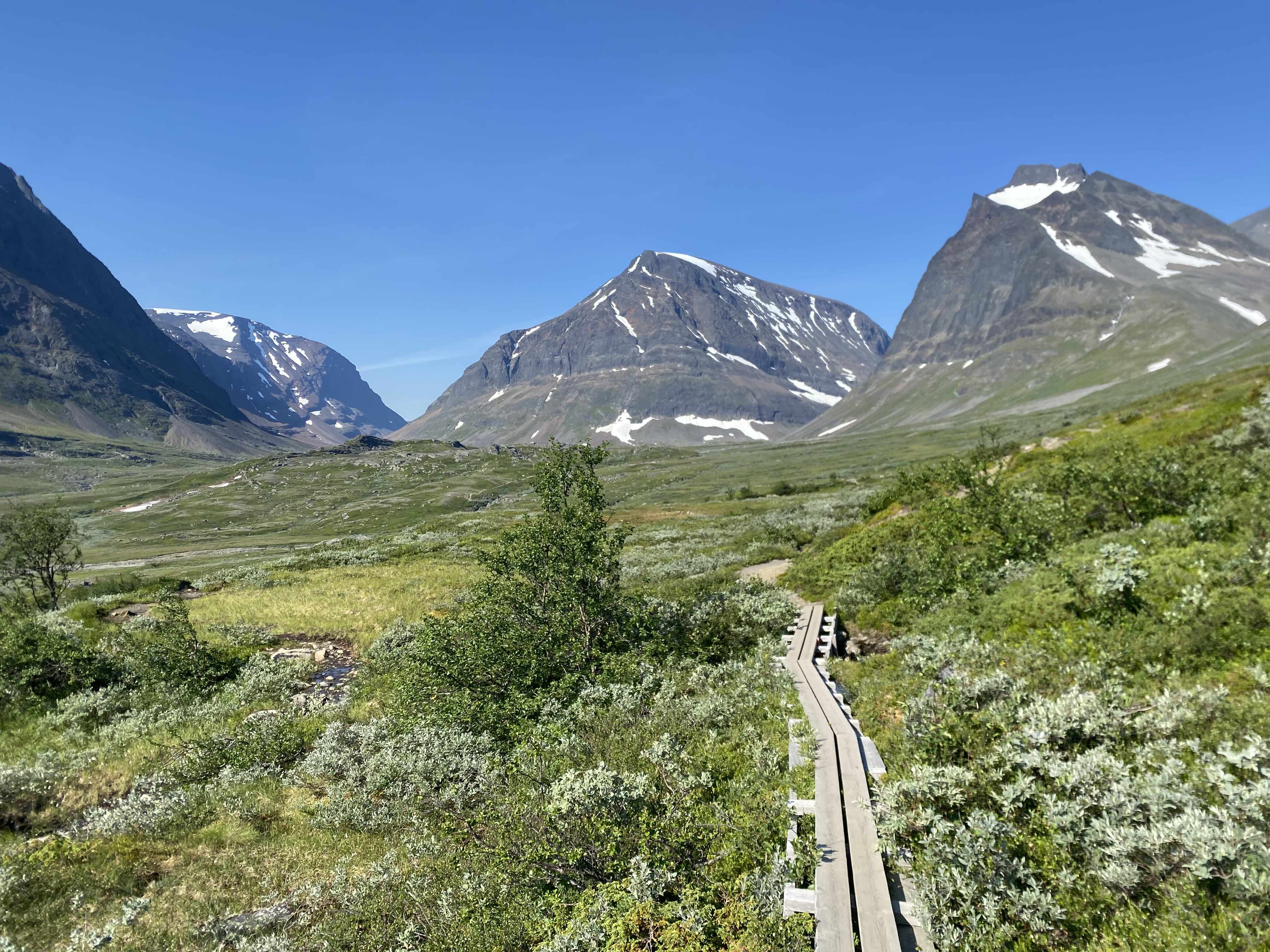
Gradually, the landscape opens up onto vast expanses of tundra dotted with rounded hills. The trail alternates between natural sections and long wooden boardwalks crossing wetlands, making progress particularly comfortable.
During the day, the mosquitoes remain relatively discreet. However, as soon as the sun disappears behind the hills, they regain all their motivation.


DAY 3 – Sälka Fjällstuga to Alesjaure Fjällstuga
25.87 km – 477 m ascent and 513 m descent
This stage leads to the Tjäktja pass, the highest point of the trek at around 1,100 metres above sea level.
Even in midsummer, several patches of snow remain, reinforcing the high-mountain feel. The descent towards Alesjaure Fjällstuga then proceeds gently through open terrain.
We set up camp by the river, facing a landscape perfectly reflected in the still water. However, this idyllic spot also holds the absolute record for mosquito density on the trip. After a quick swim and a rushed meal, the tent becomes our best refuge.


DAY 4 – Alesjaure Fjällstuga to Nissonjokk tältplats
29.81 km – 304 m ascent and 676 m descent
This is the longest day of the trek.
Despite the distance, the terrain remains very rolling, allowing a steady pace. Before reaching Nissonjokk tältplats, we enjoy a swim in the river and an unexpected respite from mosquitoes. Perhaps because it’s still daylight?
Finally, the last part of the stage follows the water in the soft light characteristic of long Arctic summer evenings. It’s one of those moments when fatigue momentarily takes a back seat.
Note that this stage can be shortened by about 9 km by staying at Abiskojaure fjällstuga, just before the lake, which helps balance the last two days better.


DAY 5 – Nissonjokk tältplats to Abisko
4.97 km – 30 m ascent and 57 m descent
This final stage is relatively short because we want to catch the train to Narvik later in the day.
Gradually, the trail descends towards Abisko, marking the end of our Kungsleden in 5 days. I make one last short detour to see the canyon west of the station, where a small path allows you to walk along it if you still have the energy.
Upon arrival at the Abisko Touriststation, we treat ourselves to a well-deserved fika – that traditional Swedish coffee break. A scale is also available, just like at the start of the trail, to compare pack weights.
Mine went from 14 kg to 11.5 kg excluding water. Clearly, we were pretty hungry during those 5 days on the Kungsleden !
From Abisko, we take the train to Narvik, Norway, to continue our Interrail trip with a magnificent mosquito-free trek, the article for which is available here: Norway – Great Crossing of the Lofotens in 7 days (+GPX).


Distance and elevation table + GPX
| Day | Start → Finish + GPX(1) | Distance | Ascent | Descent |
|---|---|---|---|---|
| 1 | Nikkaluokta → Kebnekaise Fjällstation | 19.1 km | 350 m | 152 m |
| 2 | Kebnekaise Fjällstation → Sälka Fjällstuga | 26.0 km | 526 m | 378 m |
| 3 | Sälka Fjällstuga → Alesjaure Fjällstuga | 25.9 km | 477 m | 513 m |
| 4 | Alesjaure Fjällstuga → Nissonjokk tältplats | 29.8 km | 304 m | 676 m |
| 5 | Nissonjokk tältplats → Abisko | 5.0 km | 30 m | 57 m |
| TOTAL (Full GPX) | 105.8 km | 1,687 m | 1,776 m |

(1)The GPX tracks mentioned in this article are provided for reference only. They should under no circumstances be followed as an official guide or a safe route. Mountain conditions are constantly changing and may render a route unsuitable or dangerous.
Practical tips
Budget
We were self-sufficient and, apart from hiking gear, transport, and groceries bought in Stockholm, we spent practically nothing on site.
Distance
Expect about 106 kilometres between Nikkaluokta and Abisko.
Duration
For this northern section of the Kungsleden, plan on 5 days of hiking at a brisk pace.
However, for a more comfortable pace, it’s better to add 1 to 2 days. Likewise, if you plan to climb Kebnekaise, allow 1 to 2 extra days.
Accommodation and facilities
We did the trek camping in a tent.
Around the mountain huts, many spots make it easy to set up camp. In addition, hut toilets are accessible to hikers.
From our observations, the huts appear well-maintained and regularly spaced along the route. However, we didn’t look into their reservation procedures.
The hut at Abisko, at the finish, is particularly large. It has a hiking equipment shop, a grocery store, and a restaurant.

Recommended season and mosquitoes
The best time to hike the Kungsleden runs from late June to early September.
During our visit in late July, we enjoyed very sunny weather and pleasant temperatures. On the other hand, mosquitoes were particularly numerous, especially in the evenings.
According to several hikers’ reports, their presence usually decreases from August onwards. In any case, we strongly recommend bringing a good repellent and a face net.

Transport
To reach the start of this Kungsleden section, we took the overnight train from Stockholm to Kiruna, then a local bus to Nikkaluokta. Comfortable and efficient, even though Swedish railways have a reputation for accumulating delays. Fortunately, the bus reportedly waits for the train to arrive before leaving.
From Abisko, the same railway line allows you to either head back to Stockholm or continue to Narvik in Norway.
Overnight trains must be booked well in advance during peak season, especially if you want a sleeper berth. With an Interrail pass, the supplement remains very reasonable.
History of the trail
The Kungsleden is a hiking route created in the early 20th century by the Svenska Turistföreningen (STF) to facilitate access to the mountains of northern Sweden. Its complete route now connects Abisko to Hemavan over about 450 kilometres.
The section described in this article corresponds to the Dag Hammarskjöld Trail, which connects Nikkaluokta to Abisko passing at the foot of Kebnekaise, Sweden’s highest point. It is one of the most popular sections of the Kungsleden thanks to its excellent markings, the regular presence of huts, and relatively accessible terrain.
The name Dag Hammarskjöld pays tribute to the former UN Secretary-General, who was Swedish and a mountain enthusiast.
Other multi-day hikes
Hiking fan? Find here other multi-day hiking ideas across different countries:
Leave a Reply